For the first time since 1972, humans have captured the amazing view of our planet as seen from space in a single photograph.
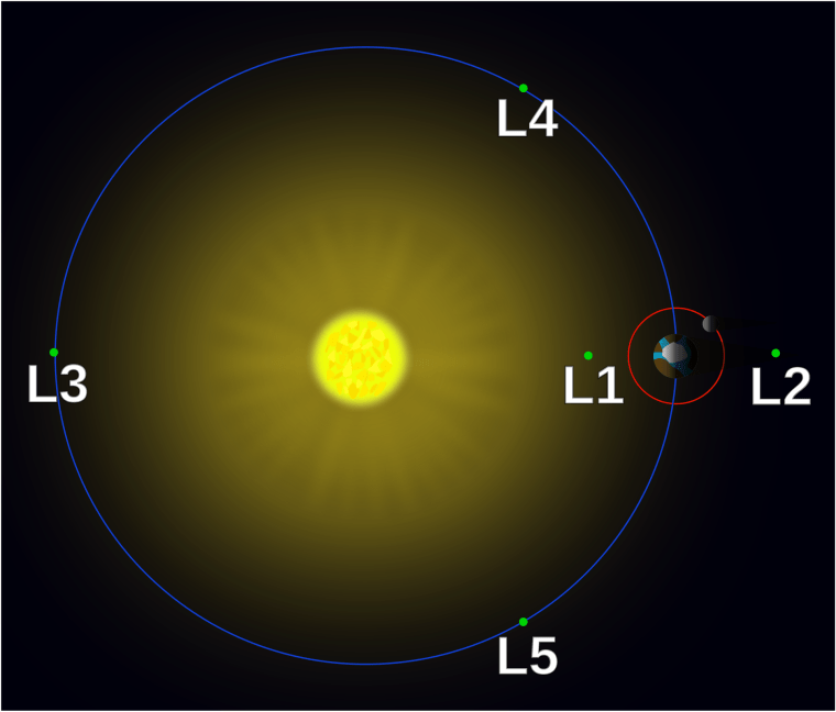
NASA's Deep Space Climate Observatory (DSCOVR) satellite released its first public image of our home this past week. The satellite was able to see the entire Earth at once because it orbits us at a distance of over a million miles, nearly four times as far away as the Moon. This orbital location has a special name, it's called the "L1 Lagrange Point".

Lagrange points are locations within a two-body system where a third smaller body can hold a stable position. They exist for the Sun-Earth system and for the Earth-Moon system. There are five such points where the math works out and they are creatively called: L1, L2, L3, L4, and L5 (as shown in the image above for the Sun-Earth system). L1, L2, and L3 are in a straight line and are at points on the near and far side of the smaller body in the system and the far side of larger body in the system, respectively. L4 and L5 are points that are leading and trailing the smaller body and they make an equilateral triangle with L3. You can explore all the past, present, and future missions to Lagrange points here.
Okay, back to the topic at hand! DSCOVR is at L1 which means it has a stable orbit that always keeps it between us and the Sun - that's why it not only has a view of the entire planet, but it also always sees the sun-lit side. The image was taken with its aptly named Earth Polychromatic Imaging Camera (EPIC). From the NASA press release:
Data from EPIC will be used to measure ozone and aerosol levels in Earth's atmosphere, as well as cloud height, vegetation properties, and the ultraviolet reflectivity of Earth. NASA will use this data for a number of Earth science applications, including dust and volcanic ash maps of the entire planet.
You can keep up to date with DSCOVR and all the epic images EPIC is sure to produce later this fall when the mission launches a dedicated website once the data processing pipeline is in place. New images should be posted every day! For more details about what to expect data-wise, check out Emily Lakdawalla's blog for The Planetary Society.
Here's some more geek that's been orbiting the interwebs:
- If you thought large animals slept standing up, think again. Here's a photo gallery of those big guys caught all curled up.
- Octopuses have been found to signal to their opponents whether they will fight or flee. [VIDEO]
- Roosters have a pecking order that determines who crows first.
- The science behind why red meat is red. [VIDEO]
- Gorgeous images of the retina from the 19th century in The Atlas of Ophthalmoscopy by Richard Liebreich.
- Artist Neil Harbisson is the world's first legally recognized cyborg.
- The complex issue of sustainability in consumer goods along the entire production chain.
- What do our daily medications look like under a microscope? Like THIS.
- Think your know our home planet pretty well? Test your knowledge with these satellite image quizzes from the Smithsonian.
- For those of you that think radiation is a bad word, you are yourself a source of radiation.
- Listen to these crazy sounds picked up by our spacecraft in the outer solar system. [AUDIO]
- A Russian entrepreneur has given $100 million to scientists looking for extraterrestrial life.
Keep on geeking!
@Summer_Ash, In-house Astrophysicist
