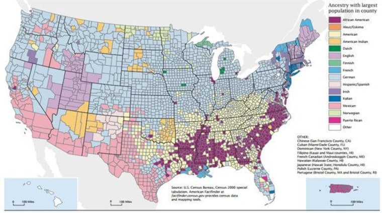
Doing some research recently on African-American voting patterns, I came upon this map of American ancestry from the U.S. Census (pdf):
And it reminded me of a mindblower of a political explanation that I meant to share here.
This is long, so meet me after the jump...
Looking at the map above, you notice the swath of African-Americans (purple) running through the southeast. Something I hadn't heard of but is apparently relatively common knowledge is that that pattern in the population is referred to as the Black Belt.
That may seem a little coarse, but it actually refers to the color and richness of the soil.
I looked for maps of soil color, but if such a thing exists, I wasn't able to find it. The clearest picture of soil distribution matching that pattern was this map of "soil orders" suggesting ultisols and/or vertisols having something to do with that color:
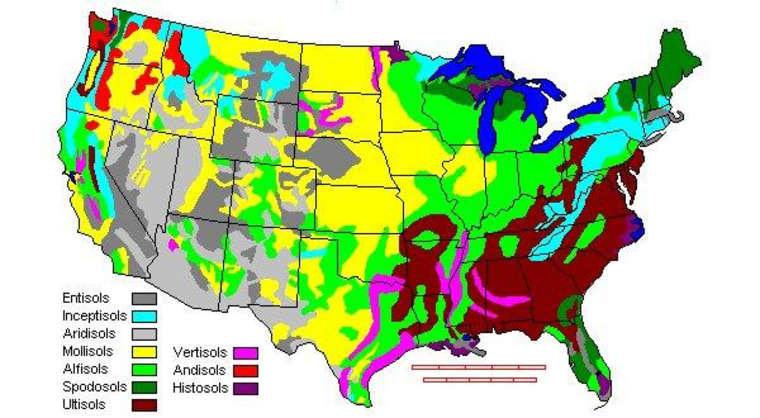
This National Science Foundation lesson on soil orders offers a more detailed version and settles the question.
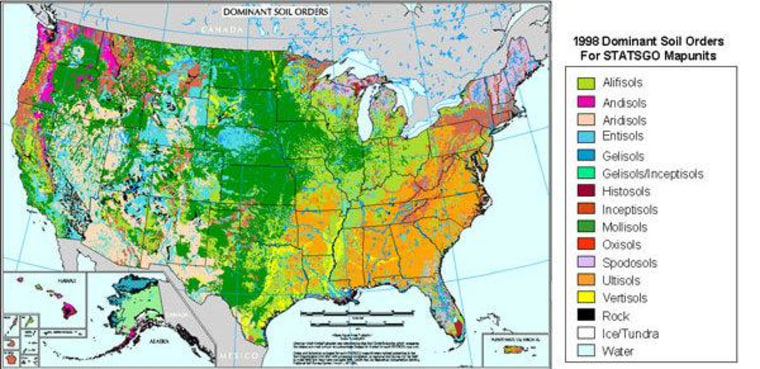
Vertisols are definitely black. (pdf) (Ultisols, not so much (pdf).)
Our friend, the google, shows how that pattern manifests today in the form of farms making use of that rich soil that comprise that lighter colored swirl.
Farms are actually the point, because while Black Belt may have been a reference to black soil, that's not to say the Black Belt doesn't also have racial meaning. Pretty much every source one checks cites this explanation from Booker T. Washington's 1901 autobiography Up From Slavery:
...The term was first used to designate a part of the country which was distinguished by the color of the soil. The part of the country possessing this thick, dark, and naturally rich soil was, of course, the part of the South where the slaves were most profitable, and consequently they were taken there in the largest numbers. Later and especially since the war, the term seems to be used wholly in a political sense—that is, to designate the counties where the black people outnumber the white.
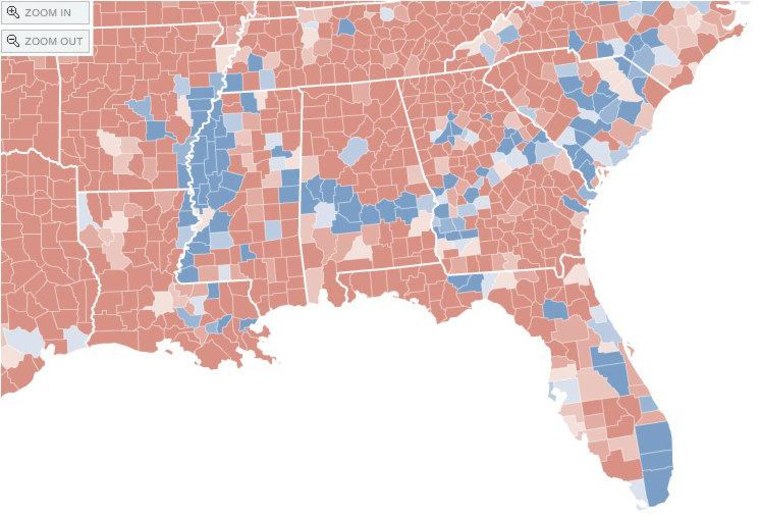
That "political sense" Washington refers to includes an electoral sense as well. Slave-descendant voters in Black Belt counties leave a blue Democratic voting stripe through otherwise red states, seen especially vividly in this New York Times county map of the 2008 election results:
I also ran into this voting pattern described as "the cotton vote." As data became available from the 2008 election, aligning a map of the blue strip of Obama-voting Black Belt counties with a map of cottom production from 1860 (!) revealed a remarkable correlation:
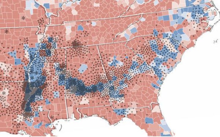
I already think that's mindblowing, but that's not even the mindblowing part. The mindblowing thing is that what's really responsible for this phenomenon of modern politics is the still-forming North American coastline of 100 million years ago.
From Deep Sea News earlier this summer:
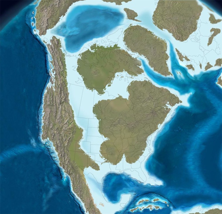
"During the Cretaceous, 139-65 million years ago, shallow seas covered much of the southern United States. These tropical waters were productive–giving rise to tiny marine plankton with carbonate skeletons which overtime accumulated into massive chalk formations. The chalk, both alkaline and porous, lead to fertile and well-drained soils in a band, mirroring that ancient coastline and stretching across the now much drier South. This arc of rich and dark soils in Alabama has long been known as the Black Belt."
Behold! Your late Cretaceous coastline and future Democratic strongholds:
Oh, what? You've still got some unblown mind left? I have a little more.
The map above represents 75 million years ago. Dr. Ron Blakey of Northern Arizona University actually offers us several maps in the late Cretaceous range. But why would that time period be particularly relevant? I find two explanations. One is that the Cretaceous was a boom time for the sort of plankton that would eventually become the Black Belt.
The other explanation is that the Cretaceous ended when, 65 million years ago, an asteroid (or asteroids) slammed into the earth, right across the future-Gulf of Mexico at the tip of the Yucatan Peninsula. Not only did the impact and resulting fallout from that asteroid kill the dinosaurs, it also wiped out huge quantities of marine life, including many of the "tiny marine plankton with carbonate skeletons" (I'm guessing some version of Coccolithophore? Anyone?) that would become the rich soil that slaves would farm on land their ancestors would inhabit in voting districts that would favor Democratic candidates around the turn of the second millennium of the Common Era.
Below is a map of the Chicxulub Crater, the crater left by the asteroid 65 million years ago, showing its location at the end of the Yucatan Peninsula. It looks like a topographical map, but actually it's a Bouguer gravity anomaly map. The best explanation I could find for gravity anomaly maps is from this Earth Observatory page from NASA.

I think the idea is that the impact created ridges of higher density, which show up as gravity anomalies. As ever, any insights and expertise you can offer on anything in this post is greatly appreciated.
Also, the more I researched this, the more I ran into people who'd already done portions or variations of it. I tried to include as many links as I could to previous work. Credit also to Allen Gathman for the cotton vote connection.
